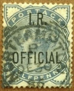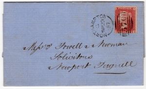
Northampton Spoon cancel of 1863
Loading map...
{"minzoom":false,"maxzoom":false,"mappingservice":"leaflet","width":"auto","height":"250px","centre":false,"title":"","label":"","icon":"","lines":[],"polygons":[],"circles":[],"rectangles":[],"copycoords":false,"static":false,"zoom":12,"defzoom":14,"layers":["OpenStreetMap"],"image layers":[],"overlays":[],"resizable":false,"fullscreen":false,"scrollwheelzoom":true,"cluster":false,"clustermaxzoom":20,"clusterzoomonclick":true,"clustermaxradius":80,"clusterspiderfy":true,"geojson":"","clicktarget":"","imageLayers":[],"locations":[{"text":"\u003Cdiv class=\"mw-parser-output\"\u003E\u003Cp\u003ENorthampton Post Office St. Giles Street\n\u003C/p\u003E\u003C/div\u003E","title":"Northampton Post Office St. Giles Street\n","link":"","lat":52.23729027466851,"lon":-0.8931858677439785,"icon":"/w/images/f/f8/Yellow_marker.png"},{"text":"\u003Cdiv class=\"mw-parser-output\"\u003E\u003Cp\u003ERoyal Mail\n\u003C/p\u003E\u003C/div\u003E","title":"Royal Mail\n","link":"","lat":52.232833009886406,"lon":-0.9125821339385193,"icon":"/w/images/a/af/Red_marker.png"},{"text":"\u003Cdiv class=\"mw-parser-output\"\u003E\u003Cp\u003ENorthampton Castle Station\n\u003C/p\u003E\u003C/div\u003E","title":"Northampton Castle Station\n","link":"","lat":52.23714904724786,"lon":-0.9062215587015316,"icon":"/w/images/c/ce/Green_marker.png"},{"text":"\u003Cdiv class=\"mw-parser-output\"\u003E\u003Cp\u003EAbington Park\n\u003C/p\u003E\u003C/div\u003E","title":"Abington Park\n","link":"","lat":52.243951684989106,"lon":-0.8721280543501421,"icon":""},{"text":"\u003Cdiv class=\"mw-parser-output\"\u003E\u003Cp\u003EAbington Square\n\u003C/p\u003E\u003C/div\u003E","title":"Abington Square\n","link":"","lat":52.24121193741793,"lon":-0.8862021673777061,"icon":""},{"text":"\u003Cdiv class=\"mw-parser-output\"\u003E\u003Cp\u003EExeter Road, now Exeter Place\n\u003C/p\u003E\u003C/div\u003E","title":"Exeter Road, now Exeter Place\n","link":"","lat":52.24278026993749,"lon":-0.8846334174432254,"icon":""},{"text":"\u003Cdiv class=\"mw-parser-output\"\u003E\u003Cp\u003EGrafton Street\n\u003C/p\u003E\u003C/div\u003E","title":"Grafton Street\n","link":"","lat":52.2424041747925,"lon":-0.9010332097693654,"icon":""},{"text":"\u003Cdiv class=\"mw-parser-output\"\u003E\u003Cp\u003EKettering Road\n\u003C/p\u003E\u003C/div\u003E","title":"Kettering Road\n","link":"","lat":52.25492795576777,"lon":-0.8745341571550352,"icon":""},{"text":"\u003Cdiv class=\"mw-parser-output\"\u003E\u003Cp\u003EKingsley Park\n\u003C/p\u003E\u003C/div\u003E","title":"Kingsley Park\n","link":"","lat":52.25072974636342,"lon":-0.8801275479574118,"icon":""},{"text":"\u003Cdiv class=\"mw-parser-output\"\u003E\u003Cp\u003EKingsthorpe\n\u003C/p\u003E\u003C/div\u003E","title":"Kingsthorpe\n","link":"","lat":52.263923122168,"lon":-0.9015765913282627,"icon":""},{"text":"\u003Cdiv class=\"mw-parser-output\"\u003E\u003Cp\u003EKingsthorpe Road\n\u003C/p\u003E\u003C/div\u003E","title":"Kingsthorpe Road\n","link":"","lat":52.25330102125432,"lon":-0.9000640464198921,"icon":""},{"text":"\u003Cdiv class=\"mw-parser-output\"\u003E\u003Cp\u003ELouise Road\n\u003C/p\u003E\u003C/div\u003E","title":"Louise Road\n","link":"","lat":52.24525286907583,"lon":-0.8936504121729478,"icon":""},{"text":"\u003Cdiv class=\"mw-parser-output\"\u003E\u003Cp\u003EMarefair\n\u003C/p\u003E\u003C/div\u003E","title":"Marefair\n","link":"","lat":52.236839510608874,"lon":-0.9026453833823948,"icon":""},{"text":"\u003Cdiv class=\"mw-parser-output\"\u003E\u003Cp\u003ENew Far Cotton\n\u003C/p\u003E\u003C/div\u003E","title":"New Far Cotton\n","link":"","lat":52.22633990293288,"lon":-0.9043432607354045,"icon":""},{"text":"\u003Cdiv class=\"mw-parser-output\"\u003E\u003Cp\u003EOverstone Road\n\u003C/p\u003E\u003C/div\u003E","title":"Overstone Road\n","link":"","lat":52.241897667888445,"lon":-0.8903700334541231,"icon":""},{"text":"\u003Cdiv class=\"mw-parser-output\"\u003E\u003Cp\u003ERegent Square\n\u003C/p\u003E\u003C/div\u003E","title":"Regent Square\n","link":"","lat":52.2419644522601,"lon":-0.898141541820083,"icon":""},{"text":"\u003Cdiv class=\"mw-parser-output\"\u003E\u003Cp\u003ESt. James' End\n\u003C/p\u003E\u003C/div\u003E","title":"St. James' End\n","link":"","lat":52.239771155134896,"lon":-0.9147204768117648,"icon":""},{"text":"\u003Cdiv class=\"mw-parser-output\"\u003E\u003Cp\u003ESemilong\n\u003C/p\u003E\u003C/div\u003E","title":"Semilong\n","link":"","lat":52.248066355469646,"lon":-0.8979611056881989,"icon":""},{"text":"\u003Cdiv class=\"mw-parser-output\"\u003E\u003Cp\u003EWellingborough Road\n\u003C/p\u003E\u003C/div\u003E","title":"Wellingborough Road\n","link":"","lat":52.25058497817452,"lon":-0.8573089435200992,"icon":""}],"imageoverlays":null}
Northampton is a town in England’s East Midlands region, in the County of Northamptonshire.
Northampton supported the Parliamentary Roundheads in the English Civil War, and Charles II ordered the destruction of the town walls and most of the castle. The Great Fire of Northampton in 1675 destroyed much of the town. It was soon rebuilt and grew rapidly with the industrial development of the 18th century.
Northampton continued to grow with the arrival of the Grand Union Canal and the railways in the 19th century, becoming a centre for footwear and leather manufacture.
The earliest reference to Northampton in writing occurred in 914 under the name Ham tune, literally meaning "home town". The prefix "North" was added later to distinguish it from other towns called Hampton, most prominently Southampton. The Domesday Book (1086) records the town as Northantone, which evolved into Norhamptone by the 13th century and later Northampton by the 17th century.
A permanent military presence was established in the town with the completion of Gibraltar Barracks in 1797.
By the end of the 18th century, Northampton had become a major centre of footwear and leather manufacture. In 1801, the population was 7,020; it more than doubled to 15,351 in 1831, attributed to the fact that there was great demand for footwear caused by the Napoleonic Wars of the late 18th and early 19th centuries. One third of the adult males alone were shoemakers at the time.
Northampton grew beyond the old town walls and industry grew rapidly with the mechanisation of factories by the middle of the 19th century.
The first railway to be built into Northampton was the Northampton and Peterborough Railway, a branch from the main London and Birmingham Railway from Blisworth to Peterborough through Northampton which opened in 1845 along with the town's first railway station, Bridge Street station. This was followed by the opening of Castle station in 1859 on the site of part of the historic Northampton Castle, and later St. John's Street station in 1872. The Northampton loop of the West Coast Main Line was built in the late 1870s. Castle station was rebuilt and expanded over the site of Northampton Castle, the remains of which were purchased and demolished in 1880 to make way for the goods shed. Bridge Street Station closed in 1964 and St John's Street closed in 1939, leaving only Castle station serving the town. It is now known simply as Northampton railway station.
Northampton was allocated the 570 Post Office Numeral
Northampton
St. Giles's Street
The Purpose built G.P.O. for the Town was built on St. Giles's Street and whilst no longer owned by the Post Office, it still functions as a post office within a store at the address.
Royal Mail Town Delivery & Sorting operation is out of St. James' Mill Road, Northampton.
Uniform Penny Postage
 Northampton to Finedon (Irthlingborough) 19 Dec 1843 |
 backside datestamps Northampton and Irthlingborough |
Other Postmarks
|
|
 Northampton Spoon cancel of 1863 |
 Northampton 1898 cover to Newmarket with Newmarket thimble on reverse.  Northampton 1898 cover to Newmarket with Newmarket thimble on reverse. |
Northampton Castle Station
Town Sub-Offices
Abington Park
Abington Square
Exeter Road
Now divided into Exeter Place/Portland Place
Grafton Street
Kettering Road
Used Telegraph code Northampton A
Kingsley Park
Kingsthorpe
Kingsthorpe Road
Louise Road
Marefair
New Far Cotton
Overstone Road
Regent Square
Used Telegraph code Northampton C
St. James' End
Used Telegraph code Northampton D
Semilong
Wellingborough Road
Used Telegraph code Northampton F
Outer Sub Offices
Loading map...
{"minzoom":false,"maxzoom":false,"mappingservice":"leaflet","width":"auto","height":"300px","centre":false,"title":"","label":"","icon":"","lines":[],"polygons":[],"circles":[],"rectangles":[],"copycoords":false,"static":false,"zoom":10,"defzoom":14,"layers":["OpenStreetMap"],"image layers":[],"overlays":[],"resizable":false,"fullscreen":false,"scrollwheelzoom":true,"cluster":false,"clustermaxzoom":20,"clusterzoomonclick":true,"clustermaxradius":80,"clusterspiderfy":true,"geojson":"","clicktarget":"","imageLayers":[],"locations":[{"text":"\u003Cdiv class=\"mw-parser-output\"\u003E\u003Cp\u003ENorthampton Post Office St. Giles Street\n\u003C/p\u003E\u003C/div\u003E","title":"Northampton Post Office St. Giles Street\n","link":"","lat":52.237290274669,"lon":-0.89318586774398,"icon":"/w/images/f/f8/Yellow_marker.png"},{"text":"\u003Cdiv class=\"mw-parser-output\"\u003E\u003Cp\u003EBrixworth\n\u003C/p\u003E\u003C/div\u003E","title":"Brixworth\n","link":"","lat":52.329744117903445,"lon":-0.9032663838445428,"icon":""},{"text":"\u003Cdiv class=\"mw-parser-output\"\u003E\u003Cp\u003EChapel Brampton\n\u003C/p\u003E\u003C/div\u003E","title":"Chapel Brampton\n","link":"","lat":52.29049781401267,"lon":-0.9324580852705702,"icon":""},{"text":"\u003Cdiv class=\"mw-parser-output\"\u003E\u003Cp\u003EDallington\n\u003C/p\u003E\u003C/div\u003E","title":"Dallington\n","link":"","lat":52.24680137072657,"lon":-0.9114042890745649,"icon":""},{"text":"\u003Cdiv class=\"mw-parser-output\"\u003E\u003Cp\u003EDuston\n\u003C/p\u003E\u003C/div\u003E","title":"Duston\n","link":"","lat":52.25964773224628,"lon":-0.9556558067797702,"icon":""},{"text":"\u003Cdiv class=\"mw-parser-output\"\u003E\u003Cp\u003EEast Haddon\n\u003C/p\u003E\u003C/div\u003E","title":"East Haddon\n","link":"","lat":52.307432464381726,"lon":-1.0218630265964148,"icon":""},{"text":"\u003Cdiv class=\"mw-parser-output\"\u003E\u003Cp\u003EGreat Brington\n\u003C/p\u003E\u003C/div\u003E","title":"Great Brington\n","link":"","lat":52.279853577525365,"lon":-1.0242077329670014,"icon":""},{"text":"\u003Cdiv class=\"mw-parser-output\"\u003E\u003Cp\u003EGreat Houghton\n\u003C/p\u003E\u003C/div\u003E","title":"Great Houghton\n","link":"","lat":52.222429256021606,"lon":-0.8407167424336802,"icon":""},{"text":"\u003Cdiv class=\"mw-parser-output\"\u003E\u003Cp\u003EGuilsborough\n\u003C/p\u003E\u003C/div\u003E","title":"Guilsborough\n","link":"","lat":52.35153105414287,"lon":-1.011244823397723,"icon":""},{"text":"\u003Cdiv class=\"mw-parser-output\"\u003E\u003Cp\u003EHardingstone\n\u003C/p\u003E\u003C/div\u003E","title":"Hardingstone\n","link":"","lat":52.21352918349522,"lon":-0.880451130212512,"icon":""},{"text":"\u003Cdiv class=\"mw-parser-output\"\u003E\u003Cp\u003EHarlestone\n\u003C/p\u003E\u003C/div\u003E","title":"Harlestone\n","link":"","lat":52.270691353517456,"lon":-0.9786251785327991,"icon":""},{"text":"\u003Cdiv class=\"mw-parser-output\"\u003E\u003Cp\u003EHarrington\n\u003C/p\u003E\u003C/div\u003E","title":"Harrington\n","link":"","lat":52.4149801038521,"lon":-0.8600832484977956,"icon":""},{"text":"\u003Cdiv class=\"mw-parser-output\"\u003E\u003Cp\u003EHolcot\n\u003C/p\u003E\u003C/div\u003E","title":"Holcot\n","link":"","lat":52.320139258220216,"lon":-0.8385386173355115,"icon":""},{"text":"\u003Cdiv class=\"mw-parser-output\"\u003E\u003Cp\u003EKislingbury\n\u003C/p\u003E\u003C/div\u003E","title":"Kislingbury\n","link":"","lat":52.23018616038662,"lon":-0.9792314781292263,"icon":""},{"text":"\u003Cdiv class=\"mw-parser-output\"\u003E\u003Cp\u003ELittle Houghton\n\u003C/p\u003E\u003C/div\u003E","title":"Little Houghton\n","link":"","lat":52.22897936042807,"lon":-0.8246770545746182,"icon":""},{"text":"\u003Cdiv class=\"mw-parser-output\"\u003E\u003Cp\u003EMears Ashby\n\u003C/p\u003E\u003C/div\u003E","title":"Mears Ashby\n","link":"","lat":52.29350598359556,"lon":-0.7699295967293379,"icon":""},{"text":"\u003Cdiv class=\"mw-parser-output\"\u003E\u003Cp\u003EMilton\n\u003C/p\u003E\u003C/div\u003E","title":"Milton\n","link":"","lat":52.19450799727766,"lon":-0.9277334595251784,"icon":""},{"text":"\u003Cdiv class=\"mw-parser-output\"\u003E\u003Cp\u003ERothersthorpe\n\u003C/p\u003E\u003C/div\u003E","title":"Rothersthorpe\n","link":"","lat":52.1940776,"lon":-0.9275371,"icon":""},{"text":"\u003Cdiv class=\"mw-parser-output\"\u003E\u003Cp\u003ESywell\n\u003C/p\u003E\u003C/div\u003E","title":"Sywell\n","link":"","lat":52.29684537751411,"lon":-0.8012022151671808,"icon":""},{"text":"\u003Cdiv class=\"mw-parser-output\"\u003E\u003Cp\u003EYardley-Hastings\n\u003C/p\u003E\u003C/div\u003E","title":"Yardley-Hastings\n","link":"","lat":52.20446300223784,"lon":-0.7360572918940183,"icon":""}],"imageoverlays":null}
Brixworth

1900 BRIXWORTH on 1d Lilac
Brixworth is a large village and civil parish in West Northamptonshire, England.The village is about 5 miles (8 km) north of Northampton next to the A508 road, now by-passed, and about 8 miles (13 km) south of Market Harborough.The place-name 'Brixworth' is first attested in the Domesday Book of 1086, where it appears as Briclesworde. The name means 'Beorhtel's or Beorhthelm's homestead or enclosure'.[
The main road from Northampton to Market Harborough passed through the village, where a number of inns served the needs of travellers for refreshment, lodging and a change of horses. The buildings of two present-day pubs in the village date back to the era of horse-drawn transport: Namely "The George Inn" & "The Coach and Horses" Both used as staging posts for resting mail horses.
The Northampton and Market Harborough railway through the parish was opened in 1859, passing 0.5 miles (800 m) west of the village. British Railways closed Brixworth railway station to passenger traffic in 1960 and closed the line to freight traffic in 1981. The trackbed of the former railway was reopened in 1993 as the Brampton Valley Way.
Chapel Brampton
Dallington
Duston
East Haddon
Great Brington
Great Houghton
Guilsborough
Hardingstone
Harlestone
Harrington
Holcot
Kislingbury
Little Houghton
Mears Ashby
Milton
Rothersthorpe
Sywell
Weston Favell
Yardley-Hastings


