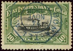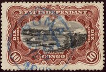
Other cancels may appear below if added.
Loading map...
{"minzoom":false,"maxzoom":false,"mappingservice":"leaflet","width":"600px","height":"250px","centre":false,"title":"","label":"","icon":"","lines":[],"polygons":[],"circles":[],"rectangles":[],"copycoords":false,"static":false,"zoom":12,"defzoom":14,"layers":["OpenStreetMap"],"image layers":[],"overlays":[],"resizable":false,"fullscreen":false,"scrollwheelzoom":true,"cluster":false,"clustermaxzoom":20,"clusterzoomonclick":true,"clustermaxradius":80,"clusterspiderfy":true,"geojson":"","clicktarget":"","imageLayers":[],"locations":[{"text":"","title":"","link":"","lat":-5.835038,"lon":13.064686,"icon":""}],"imageoverlays":null}
Boma is a port town on the Congo River, some 100 km upstream from the Atlantic Ocean, in the Bas-Congo province of the Democratic Republic of the Congo. Boma was the capital city of the Congo Free State and Belgian Congo (the modern Democratic Republic of the Congo) from 1 May 1886 to 1926, when the capital was moved to Léopoldville (since renamed Kinshasa). The port handles exports of tropical timber, bananas, cacao, and palm products.Boma was founded as a slaving station and entrepôt by merchants of several European countries in the 16th century. Trade was chiefly in the hands of Dutch merchants, but British, French and Portuguese firms also had factories there. No European power exercised sovereignty, though claims were from time to time put forward by Portugal.
Postmark Examples
Democratic Republic of Congo
Belgian Congo Era
 Circle BOMA used in 1911. |
|
Congo Independent State
|
|
 Blue octogone BOMA TEL. A.E. in 1908. |


