Kingborough Council is an urban LGA (37,734 inhabitants in 2018) in Tasmania, and one of the five municipalities that constitutes the Greater
Hobart Area.
Loading map...
{"minzoom":false,"maxzoom":false,"mappingservice":"leaflet","width":"auto","height":"250px","centre":false,"title":"","label":"","icon":"","lines":[],"polygons":[],"circles":[],"rectangles":[],"copycoords":false,"static":false,"zoom":10,"defzoom":14,"layers":["OpenStreetMap"],"image layers":[],"overlays":[],"resizable":false,"fullscreen":false,"scrollwheelzoom":true,"cluster":false,"clustermaxzoom":20,"clusterzoomonclick":true,"clustermaxradius":80,"clusterspiderfy":true,"geojson":"","clicktarget":"","imageLayers":[],"locations":[{"text":"","title":"","link":"","lat":-43.1932,"lon":147.2632,"icon":""}],"imageoverlays":null}
Postmarks in Australia
Postmarks in British Tasmania
Before 1913.
BARNES BAY
Loading map...
{"minzoom":false,"maxzoom":false,"mappingservice":"leaflet","width":"auto","height":"250px","centre":false,"title":"","label":"","icon":"","lines":[],"polygons":[],"circles":[],"rectangles":[],"copycoords":false,"static":false,"zoom":12,"defzoom":14,"layers":["OpenStreetMap"],"image layers":[],"overlays":[],"resizable":false,"fullscreen":false,"scrollwheelzoom":true,"cluster":false,"clustermaxzoom":20,"clusterzoomonclick":true,"clustermaxradius":80,"clusterspiderfy":true,"geojson":"","clicktarget":"","imageLayers":[],"locations":[{"text":"\u003Cdiv class=\"mw-parser-output\"\u003E\u003Cp\u003EBarnes Bay\n\u003C/p\u003E\u003C/div\u003E","title":"Barnes Bay\n","link":"","lat":-43.1167,"lon":147.367,"icon":"/w/images/a/af/Red_marker.png"}],"imageoverlays":null}
Barnes Bay is a rural locality (only 22 inhabitants in 2016) on Bruny Island in the Local Government Area (LGA) of Kingborough in the Hobart LGA region of Tasmania. The locality is about 35 km south (by ferry) of the town of Kingston.
Barnes Bay Post Office opened on 20 October 1851 and closed in 1969. Known as Kelly's Point from 1853 until 1906.
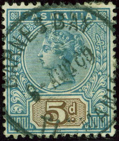 Circle BARNES BAY in 1909. |
_TAS_a.jpg)
_a.jpg)
_TAS_a.jpg)