Loading map...
{"minzoom":false,"maxzoom":false,"mappingservice":"leaflet","width":"auto","height":"200px","centre":false,"title":"","label":"","icon":"","lines":[],"polygons":[],"circles":[],"rectangles":[],"copycoords":false,"static":false,"zoom":12,"defzoom":14,"layers":["OpenStreetMap"],"image layers":[],"overlays":[],"resizable":false,"fullscreen":false,"scrollwheelzoom":true,"cluster":false,"clustermaxzoom":20,"clusterzoomonclick":true,"clustermaxradius":80,"clusterspiderfy":true,"geojson":"","clicktarget":"","imageLayers":[],"locations":[{"text":"","title":"","link":"","lat":-39.493633,"lon":176.911639,"icon":""},{"text":"\u003Cdiv class=\"mw-parser-output\"\u003E\u003Cp\u003EPort Ahuriri\n\u003C/p\u003E\u003C/div\u003E","title":"Port Ahuriri\n","link":"","lat":-39.480871,"lon":176.897944,"icon":"/w/images/2/2c/Pink_marker.png"}],"imageoverlays":null}
Napier is a New Zealand city with a seaport, located in Hawke's Bay on the eastern coast of the North Island. Napier has well-documented Māori history. When the Ngāti Kahungunu party of Taraia reached the district many centuries ago, the Whatumamoa, Rangitane and the Ngāti Awa and elements of the Ngāti Tara iwi existed in the nearby areas of Petane, Te Whanganui-a-Orotu and Waiohiki. Later, the Ngāti Kahungunu became the dominant force from Poverty Bay to Wellington. They were one of the first Māori tribes to come in contact with European settlers.
The Port was formerly known as Port Ahuriri the Maori name this area of port is still called Ahuriri. The town name has now been changed from Ahuriri to Napier.
Napier cancels
 Port Ahuriri cancel with linear Napier cachet applied |
Ahuriri cancels
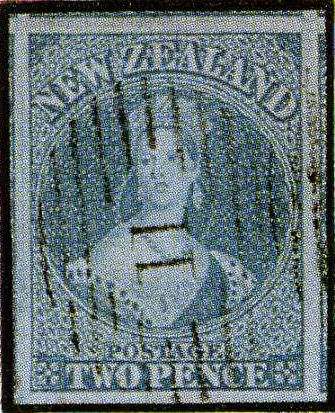 Numeral 11 on a 1855 issue. |
 AHURIRI on a 1882 issue (1n 1900?). |
Covers
 Port Ahuriri cancel with Napier cachet applied  |
_N_a.jpg)
_11.jpg)
_A_b.jpg)
_A_a.jpg)

