The Shire of Moyne is a Local Government Area in the Barwon South West region of Victoria, Australia, located in the south-western part of the state.
It covers an area of 5,481 km² and in June 2018 had a population of (only) 16,887. It includes the towns of Port Fairy [Council Seat], Koroit, Mortlake, Macarthur, Peterborough, Caramut, Ellerslie, Framlingham, Garvoc, Hawkesdale, Kirkstall, Panmure, Mailors Flat, Purnim, Wangoom and Woolsthorpe. It also entirely surrounds the City of Warrnambool, a separate local government area. It was formed in 1994 from the amalgamation of the Shire of Belfast, Shire of Minhamite,
Borough of Port Fairy, and parts of the Shire of Mortlake, Shire of Warrnambool, Shire of Dundas, Shire of Mount Rouse and Shire of Hampden
Loading map...
{"minzoom":false,"maxzoom":false,"mappingservice":"leaflet","width":"auto","height":"250px","centre":false,"title":"","label":"","icon":"","lines":[],"polygons":[],"circles":[],"rectangles":[],"copycoords":false,"static":false,"zoom":8,"defzoom":14,"layers":["OpenStreetMap"],"image layers":[],"overlays":[],"resizable":false,"fullscreen":false,"scrollwheelzoom":true,"cluster":false,"clustermaxzoom":20,"clusterzoomonclick":true,"clustermaxradius":80,"clusterspiderfy":true,"geojson":"","clicktarget":"","imageLayers":[],"locations":[{"text":"","title":"","link":"","lat":-38.367,"lon":142.233,"icon":""}],"imageoverlays":null}
Postmark in Australia
Postmarks in British Victoria
Before 1913.
MORTLAKE
Mortlake is a small town (1,073 inhabitants in 2011) in the Western District of Victoria, Australia on the Hamilton Highway, 50 km north-east of Warrnambool. It is in the Shire of Moyne local government area and the federal Division of Wannon.
Loading map...
{"minzoom":false,"maxzoom":false,"mappingservice":"leaflet","width":"auto","height":"250px","centre":false,"title":"","label":"","icon":"","lines":[],"polygons":[],"circles":[],"rectangles":[],"copycoords":false,"static":false,"zoom":11,"defzoom":14,"layers":["OpenStreetMap"],"image layers":[],"overlays":[],"resizable":false,"fullscreen":false,"scrollwheelzoom":true,"cluster":false,"clustermaxzoom":20,"clusterzoomonclick":true,"clustermaxradius":80,"clusterspiderfy":true,"geojson":"","clicktarget":"","imageLayers":[],"locations":[{"text":"","title":"","link":"","lat":-38.067,"lon":142.8,"icon":""}],"imageoverlays":null}
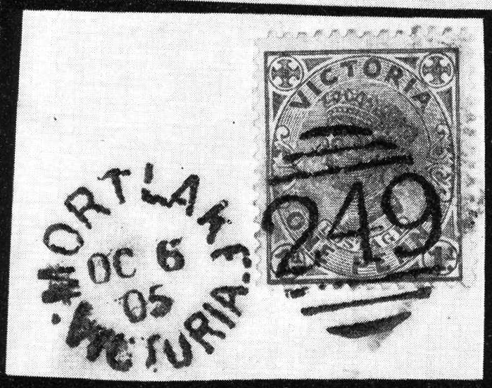 Duplex cancel in 1905, numeral 249. Auction image. |
_BV_Mortlake_a.jpg)
_a.jpg)
_BV_a.jpg)