Loading map...
{"minzoom":false,"maxzoom":false,"mappingservice":"leaflet","width":"auto","height":"300px","centre":false,"title":"","label":"","icon":"","lines":[],"polygons":[],"circles":[],"rectangles":[],"copycoords":false,"static":false,"zoom":11,"defzoom":14,"layers":["OpenStreetMap"],"image layers":[],"overlays":[],"resizable":false,"fullscreen":false,"scrollwheelzoom":true,"cluster":false,"clustermaxzoom":20,"clusterzoomonclick":true,"clustermaxradius":80,"clusterspiderfy":true,"geojson":"","clicktarget":"","imageLayers":[],"locations":[{"text":"","title":"","link":"","lat":51.238803,"lon":7.102866,"icon":""}],"imageoverlays":null}
Sonnborn was a former independent mayor's office that was divided and dissolved in 1888. The core of Sonnborn was incorporated into Elberfeld and today forms the residential area of Sonnborn in the Elberfeld-West district of Wuppertal.
What links to here?
Postmark Examples
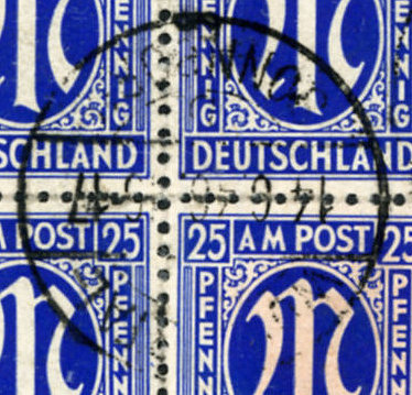 WUPPERTAL-SANNBORN b 14.6.46 |
 WUPPERTAL-SANNBORN b 13.4.46 |
_a.jpg)
_ao.jpg)