Düsseldorf is the capital city (598,686 end 2013) of the German state of North Rhine-Westphalia. Historically, a District in the Rheinland province of Prussia. It was an important railway station, with train mounted post-offices (Bahnpost) since 1852. The city counts 50 boroughs, split in 10 Districts.
Loading map...
{"minzoom":false,"maxzoom":false,"mappingservice":"leaflet","width":"auto","height":"300px","centre":false,"title":"","label":"","icon":"","lines":[],"polygons":[],"circles":[],"rectangles":[],"copycoords":false,"static":false,"zoom":11,"defzoom":14,"layers":["OpenStreetMap"],"image layers":[],"overlays":[],"resizable":false,"fullscreen":false,"scrollwheelzoom":true,"cluster":false,"clustermaxzoom":20,"clusterzoomonclick":true,"clustermaxradius":80,"clusterspiderfy":true,"geojson":"","clicktarget":"","imageLayers":[],"locations":[{"text":"","title":"","link":"","lat":51.23,"lon":6.78,"icon":""}],"imageoverlays":null}
Postmarks in Unified Germany
Meter cancels (all districts and periods)
 Meter cancel Dusseldorf-Holthausen 1935. |
 Meter cancel Dusseldorf 1955. |
 Meter cancel Dusseldorf-11 1956. |
 Meter cancel Dusseldorf-Holthausen 1958. |
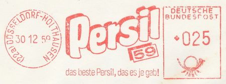 Meter cancel Dusseldorf-Holthausen 1959. |
 Meter cancel Dusseldorf 1963. |
 Meter cancel Dusseldorf 1967. |
 Meter cancel Dusseldorf 1973. |
 Meter cancel Dusseldorf-Flughafen 1973. |
 Meter cancel Dusseldorf 1973. |
 Meter cancel Düsseldorf 1993. |
 Meter cancel Düsseldorf-1 1998. |
|
|
 Meter cancel Düsseldorf 2007. |
BRIEFZENTRUM 40
 "Hier geht die Post ab" town promotion cancel |
Postmarks in Federal Republic of Germany
 Düsseldorf to Melrose, Massachusetts in 1969. |
Allied Occupied Germany
RPD Düsseldorf, PLZ 22a, was in the British Zone of occupation.
Düsseldorf 1
 DÜSSELDORF 1 v 22.7.46.-20 |
 DÜSSELDORF 1 v 7.5.46.--9 |
 DÜSSELDORF 1 ll -5.6.46.-16 |
|
Düsseldorf 10
 Off-centered (22) DÜSSELDORF 10 bb 18.9.45.-13 |
Machine Postmarks
 Machine Cancel DÜSSELDORF 1 oo 25.5.46. |
 Machine Cancel (Roller cancel?) DÜSSELDORF 1 oo 28.2.46. |
Slogan Postmarks
 "Vergiss nicht Strasse und Hausnummer anzugeben." (DÜSSELDORF 1 t 13.10.45. 9 |
 "Vergiss nicht Strasse und Hausnummer anzugeben." (22 DÜSSELDORF 1 ok 29.1.46. 9 |
Cash Register Postmarks
Covers
Machine Cancel (22) DÜSSELDORF 1 oo dated 28.2.46.-19 correctly franked with 12 Pfennig to pay the Distant Letter rate of the 1st rate period on its last day. Rates doubled on March 1st.
Postmarks in German Empire (1872-1945)
Since 1 January 1872.
 Horseshoe Hufeisen in 1872ca |
 Horseshoe Hufeisen in 1872 |
 3-lines frame in 1876, to be identified. |
 Circle at Düsseldorf 2 in 1881. |
|
|
 Bridge in August 1913. Mi86I |
|
 Bridge in March 1922. Mi171 |
|
|
 Michel No. 399X, 10+10 Pf., "Düsseldorf", 31-12-1926 |
 DÜSSELDORF in rectangular box. |
Special cancellers
 Reichsausstellung in 1937, circle DÜSSELDORF 1 k0 on 3-12-36. |
OBERKASSEL
Oberkassel (Limburgish: Ueverkassel) is a part of Düsseldorf's district 4, with a population of about 17,000 inhabitants. Oberkassel lies on the west side of the river Rhine. The Oberkassel Bridge between Düsseldorf-Heerdt and Düsseldorf was opened in 1898. Heerdt (with Oberkassel, became a part of Düsseldorf in 1909.
Loading map...
{"minzoom":false,"maxzoom":false,"mappingservice":"leaflet","width":"auto","height":"300px","centre":false,"title":"","label":"","icon":"","lines":[],"polygons":[],"circles":[],"rectangles":[],"copycoords":false,"static":false,"zoom":13,"defzoom":14,"layers":["OpenStreetMap"],"image layers":[],"overlays":[],"resizable":false,"fullscreen":false,"scrollwheelzoom":true,"cluster":false,"clustermaxzoom":20,"clusterzoomonclick":true,"clustermaxradius":80,"clusterspiderfy":true,"geojson":"","clicktarget":"","imageLayers":[],"locations":[{"text":"","title":"","link":"","lat":51.2303,"lon":6.755,"icon":""}],"imageoverlays":null}
RATH
Rath is a borough (16,975 inhabitants in 2000) in Düsseldorf District 6, near the airport, northeast of the city center. In 1909 Rath together with Unterrath and Lichtenbroich were incorporated into Düsseldorf at their own request.
Loading map...
{"minzoom":false,"maxzoom":false,"mappingservice":"leaflet","width":"auto","height":"300px","centre":false,"title":"","label":"","icon":"","lines":[],"polygons":[],"circles":[],"rectangles":[],"copycoords":false,"static":false,"zoom":12,"defzoom":14,"layers":["OpenStreetMap"],"image layers":[],"overlays":[],"resizable":false,"fullscreen":false,"scrollwheelzoom":true,"cluster":false,"clustermaxzoom":20,"clusterzoomonclick":true,"clustermaxradius":80,"clusterspiderfy":true,"geojson":"","clicktarget":"","imageLayers":[],"locations":[{"text":"","title":"","link":"","lat":51.268,"lon":6.814,"icon":""}],"imageoverlays":null}
Postmarks in North German Confederation (1868-1871)
Postmarks in Prussia Rheinland province
Kreis DÜSSELDORF used a Postal code 359, capital of the District.
KAISERSWERTH
Kaiserswerth is one of the oldest parts of the City, located in the north and next to the river Rhine.
Kaiserswerth has about 7,000 inhabitants. A borough in the 5th District, known for the Kaiserpfalz ruins. In 1174, Friederick I Barbarossa moved the Rhine customs collection to Kaiserswerth - hence the name. It joined the city in the 1929 reform.
Loading map...
{"minzoom":false,"maxzoom":false,"mappingservice":"leaflet","width":"auto","height":"300px","centre":false,"title":"","label":"","icon":"","lines":[],"polygons":[],"circles":[],"rectangles":[],"copycoords":false,"static":false,"zoom":13,"defzoom":14,"layers":["OpenStreetMap"],"image layers":[],"overlays":[],"resizable":false,"fullscreen":false,"scrollwheelzoom":true,"cluster":false,"clustermaxzoom":20,"clusterzoomonclick":true,"clustermaxradius":80,"clusterspiderfy":true,"geojson":"","clicktarget":"","imageLayers":[],"locations":[{"text":"","title":"","link":"","lat":51.3,"lon":6.739,"icon":""}],"imageoverlays":null}
The KAISERSWERTH post office used a code 697, Kreis Düsseldorf.
_mc7.jpg)
_mc1955.jpg)
_mc1956.jpg)
_mc3.jpg)
_mc8.jpg)
_mc1963.jpg)
_mc1967.jpg)
_mc9.jpg)
_mc9a.jpg)
_mc1973.jpg)
_mc4.jpg)
_mc1986.jpg)
_mc2.jpg)
_mc5.jpg)
_mc1993.jpg)
_mc1998.jpg)
_mc1998a.jpg)
_mc1.jpg)
_mc2005.jpg)
_mc2007.jpg)
_mc2008.jpg)
_mc6.jpg)
_mc2015.jpg)
_mc2017.jpg)
_ug.jpg)
_cover_10_Jan_1969.jpg)
_a.jpg)
_ao1v.jpg)
_ao.jpg)
_ao_1_x.jpg)
_ao2.jpg)
_am_ms.jpg)
_am.jpg)
_ao_sc.jpg)
_ao_sc2.jpg)
_am_RKS.jpg)
_am_cov_ms.jpg)
_DRRH_a.jpg)
_DRRH_b.jpg)
_DRRH_1876.jpg)
_DRRH_1881.jpg)
_a.jpg)
_DRRH_1913.jpg)

_DRRH_d.jpg)


_DRRH_c.jpg)
_DRRH_Ausstellung_1937a.jpg)
_OBK_DRRH_a.jpg)
_RAT_DRRH_a.jpg)
_NPB_a.jpg)
_PRRH_KAIS_a.jpg)
_NPB_b.jpg)
_PRRH_a.jpg)
_PRRH_b.jpg)