Category:Germany-Allied Occ
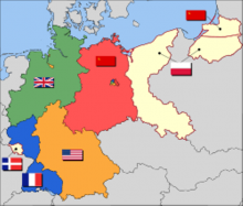
Stamps of Allied occupation zones in Germany 1945-1949 LARGE SCALE MAP OF GERMANY (and surroundings) SHOWING THE OCCUPIED ZONING POST WWII
To see only pages that require images (have placeholders with no image) visit : Germany-Allied Occ Image Requirements
The Allied powers who defeated Nazi Germany in World War II divided the country west of the Oder–Neisse line into four occupation zones for administrative purposes during 1945–1949. In autumn 1944 the three powers (still without France) had agreed upon the zonal makeup by the London Protocol. In the closing weeks of fighting in Europe, United States forces had pushed beyond the agreed boundaries for the future zones of occupation, in some places by as much as 200 miles (320 km). The line of contact between Soviet and American forces at the end of hostilities was temporary. After two months in which they had held areas that had been assigned to the Soviet zone, U.S. forces withdrew in the first days of July 1945. Some have concluded that this was a crucial move that persuaded the Soviet Union to allow American, British, and French forces into their predesignated sectors in Berlin, which occurred at roughly the same time (July 1945), although the need for intelligence gathering (see Operation Paperclip) may also have been a factor.
Subcategories
This category has the following 6 subcategories, out of 6 total.
A
B
F
G
R
Pages in category "Germany-Allied Occ"
The following 54 pages are in this category, out of 54 total.
- Germany-Allied Occ 1945 Russian Zone, Thuringia Definitives
- Germany 1945 Definitives - Province Saxony - imperforate - I
- Germany-Allied Occ 1945 French Zone, General Issues - Arms
- Germany 1945 Definitives - Province Saxony - perforate
- Germany-Allied Occ 1945 Definitives (Washington Print)
- Germany-Allied Occ 1945 Soviet Zone,West Saxony Definitives - III
- Germany-Allied Occ 1945 Soviet Zone,West Saxony Definitives
- Germany-Allied Military Occupation 1945 Definitives (German Print)
- Germany-Allied Military Occupation 1945 Definitives 1pf
- Germany-Allied Occ 1945 Berlin-Brandenburg Definitives
- Germany-Allied Occ 1945 Russian Zone, Mecklenburg-Vorpommern Definitives
- Germany-Allied Occ 1945 Definitives (London Print)
- Germany-Allied Occ 1945 Russian Zone, West Saxony Definitives
- Germany-Allied Occ 1945 Russian Zone, Saxony Definitives
- Germany-Allied Occ 1946 Russian Zone, Thuringia, Bridges rebuilding
- Germany 1946 Province Saxony - Charity
- Germany-Allied Occ 1946 American, British & Russian Zone Definitives
- Germany-Allied Occ 1947 French Zone, Rhineland Definitives
- Germany-Allied Occ 1947 French Zone, Baden Definitives
- Germany-Allied Occ 1947 Leipzig Tade Fair 1947
- Germany-Allied Occ 1947 Leipzig Spring Fair
- Germany-Allied Occ 1947 American, British & Russian Zone Definitives
- Germany-Allied Occ 1947 French Zone, Wuttemberg Definitives
- Germany-Allied Occ 1948 Berlin-Brandenburg Definitives with overprint
- Germany-Allied Occ 1948 Definitives British & American Zones Large Overprint
- Germany-Allied Occ 1948 Definitives British & American Zones Small Overprint
- Germany-Allied Occ 1948 Soviet Zone, definitives, hand-cancellation
- Germany-Allied Occ 1948 British and American Zone 700th Anniversary Cologne Cathedral
- Germany-Allied Occ 1948-1951 British & American Zones perf 14
- Germany-Allied Occ 1948 Definitives British & American Zones - Buildings
- Germany-Allied Occ 1948 Russian Zone, General Issues Definitives - Famous Germans
- Germany-Allied Occ 1948 Obligatory Relief Tax Stamp
A
- Abenberg (DE)
- Abtswind (DE)
- Adelsdorf (DE)
- Adelshofen (DE)
- Adelsried (DE)
- Affing (DE)
- Aholming (DE)
- Ahorn (DE-BV)
- Ahorntal (DE)
- Aicha vorm Wald (DE)
- Aindling (DE)
- Ainring (DE)
- Aiterhofen (DE)
- Albertshofen (DE)
- Aldersbach (DE)
- Allershausen (DE)
- Altdorf - kreis Landshut (DE)
- Alteglofsheim (DE)
- Altendorf - Kreis Bamberg (DE)
- Asbach-Baumenheim (DE)

